
I am well aware of the fact that there are maps on my phone. I use the internet constantly when planning trips. I also love† good old-fashioned paper maps.
I wanted a map of Europe with specific details for planning rail travel. I’d narrowed it down to two brands readily available on Amazon.com, but couldn’t find a single review comparing them both. Today, I’ll try to remedy that for other cartophiles or Luddites with European dreams.
I’ll be comparing the Streetwise Laminated Europe & Major Rail Lines with Rick Steves Europe Planning Map.
 I specifically chose to assess laminated or coated paper maps that resist tears and spills because those make the most sense for the rigors of travel. Murphy’s Law suggests that we are most likely to get lost after the downpour begins; I’d like my map to function regardless of the weather.
I have also, on occasion, been known to knock over a glass of wine or slosh coffee as the trip planning process gets me all keyed up. The caffeine and alcohol might also factor in this scenario, but I do tend to be excitable even in the absence of stimulants.
Once travel has commenced, I pick up free, local tourist maps commonly available in major tourist centers to get my bearings in a new town. I refer to my phone for turn by turn directions to specific addresses. Still, there is something about taking the large view on an unfolded map that feels like a first step into a journey.
Also, Americans don’t learn enough Geography in school. I certainly didn’t, and, even after a few years’ extra practice as an adult due to my child learning at home*, the major cities remain numerous and the world large. I need reference materials.
I almost always know which country is home to a city, and where the nation fits into its region, but exactly where Cologne sits in Germany, or which Belgian cities are near the border with Luxembourg? Um, no. All of this was exacerabated by a minor obsessions with European micro states that I spent time studying in 2017. Those tiny nations are hardly visible on a computer monitor sized map of the continent.
Then add my interest in how particular cities are connected by Europe’s vast railroad network. Having looked up—perhaps even purchased—train tickets from point A to point B, it’s not immediately obvious how the line that connects them is shaped.
It’s rarely a straight line that the crow might fly. Mountains, rivers, and international treaties dictated these connections.
I want to learn something about the intermediate areas through which my train will pass. Will they be scenic? Gritty? Could I make a quick stop in a place whose name or reputation I’ve been hearing all my life?
History and politics laid down the tracks that interconnect European places as much as geography did. That stuff is interesting,** and complicated. A good map provides me with clues about where to start looking when I want to understand a place. Researching intermediate stops can lead me to the kind of historical and cultural discoveries at the heart of why I love travel.
Streetwise Laminated Europe & Major Rail Lines: Most portable, with just enough detail to get the big picture
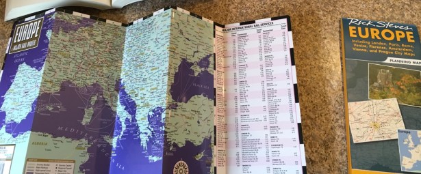
- Size, folded 4″ x 8 ½″
- Size, unfolded 20″ x 8 ½″
- Scale 1:11,500,000
- Revised 01/2018
- Retail price $6.95
- ISBN-10 2067230042
- ISBN-13 978-2067230040
I’ve been a fan of the moderately sized, quick fold Streetwise maps for decades now. They were actually out of print for a while, but appear to be back in production as of early 2018.
For use during a trip, Streetwise produces my favorite format. With zigzag folds in one direction only, even the origami-cally challenged will easily whip these in and out of a bag or pocket. They can be consulted on airline tray tables or in crowded cafes with petite bistro furnishings. I challenge anyone to fail at folding this map!
If you plan to purchase only one overview map of Europe, and you expect to carry it with you, my first recommendation is the Streetwise laminated Europe & Major Rail Lines.
That said, you don’t get a whole lot of detail at a size roughly double a standard sheet of notebook paper. This is a great reference for “where am I relative to the continent of Europe” and fairly awful for “which way to the cathedral?”
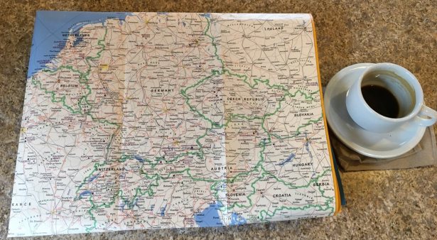
Compared to the Rick Steves Europe map, Streetwise does show a lot more of Central and Eastern Europe. I don’t think I speak out of turn when I point out than many of us struggle more with placing these countries–many of which didn’t exist as independent states when I was a student–on a map. Their presence here is a great help to me.
If you will travel anywhere east of Italy, Austria, and the Czech Republic, you will find Streetwise a better choice than Rick Steves.
Rick Steves Europe Planning Map: Better detail, bigger format, sturdy enough, fussier whilst on the move
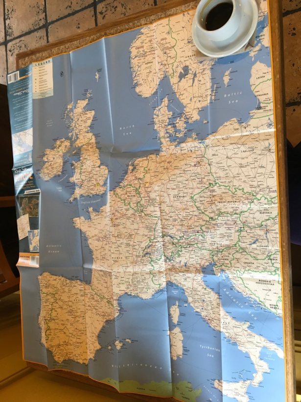
- Size, folded 4 ¼″ x 9 ½″
- Size, unfolded 25″ x 28″
- Scale not stated anywhere I could find on the map or the manufacturer’s web site!
- © 2017
- Retail price $9.99
- ISBN-10 1598801376
- ISBN-13 978-1598801378
If you’re ordering a Rick Steves map, make sure you’ve selected a listing for the simple map as opposed to the more popular, larger, heavier, more expensive travel guidebook. Buy one on Amazon if you can find it for its retail price, or order direct from the publisher.
Rick Steves (the brand) is better known for guidebooks, tour service, and PBS television episodes than for maps. Fans of the eponymous host seem inclined to buy many product with the famous name attached, however, including luggage and accessories.
You should only buy this map for travel if you know how to fold a map. Can’t fold a map to save your life? Get a Streetwise instead!
I found that I could back fold the Rick Steves Europe map to highlight exactly the area in which I was interested, taking back my cafe table real estate and reducing the likelihood that I would spill my espresso on it. Then again, I don’t struggle with map folding in general.
Coated paper is easier to re-fold than standard thin map paper to my moderately experienced hands. Some Amazon reviewers complained that the Rick Steves map was difficult to fold after use.

In addition to the large image of primarily Western Europe on its face, this map offers a helpful inset showing Cost & Time by rail between major cities. Then again, as of 2018, I can pull data like this up on my phone in seconds.
For anyone considering rail travel in the UK or Europe, you will also do better to consult The Man in Seat 61 for general train travel information instead of the likely outdated printed figures on any map or in any guidebook. The host of that enormously helpful website also pops up to help other travelers personally on TripAdvisor forums from time to time. He is the expert for this kind of travel today.
This inset is nice, but of only limited use. It isn’t enough to make me prefer this map.
 Far, far worse in my opinion is the enormous waste of space given to more than two full panels of precious map real estate for placement of ads promoting other Rick Steves goods and services. Having paid cash for this map, I’m insulted by the presence of advertising at this scale upon it.
I would have been unimpressed but tolerant of a slip of paper tucked inside with such information, though I’d resent the necessity, then, of wasteful shrink wrapping of the map to keep it contained therein until I could pitch it into my recycle bin.
There is zero chance I will suddenly feel compelled to sign up for an expensive group tour in the middle of my European travels. I’m similarly unlikely to buy American guidebooks in foreign countries where they command a premium price as imports. This is money grubbing, plain and simple, and offers nothing to an independent traveler.
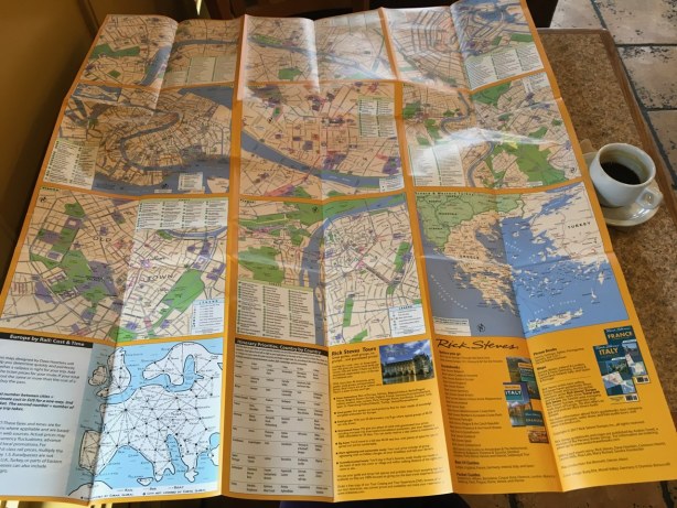 Before the modern era (i.e., my phone getting smarter than a chimp), I would have considered the city map insets that fill the rest of the back side of Rick Steves Europe Planning Map as of probable value to some travelers. Included cities are Amsterdam, Florence, London, Paris, Prague, Rome, Venice, and Vienna.
I used to buy unique city maps for most destinations where I intended to spend much time. In the early internet era, I would print out localized views of the area around attractions of special interest or the neighborhood around my hotel. Now, with my phone a ubiquitous back up plan, I rarely do.
There might be tourists who will find these city view insets of value, but I’m not one of them, nor was I in the pre-smartphone era. It’s too much trouble to fold a large map to view just the desired city in this format, and the amount of information provided isn’t worth carrying around the bulk of a full sized map. Tourist office and hotel lobby offerings will serve most of us much better, usually for free or at a very minimal fee.
In my opinion, the back side of the Rick Steves Planning Map should have included the rest of Europe at a scale similar to the front. I would find it a much more useful tool if it had.
The ninth inset on the back is a bit of southeastern Europe: Greece and Western Turkey. Perhaps that’s as far to the east as the Rick Steves demographic is willing to travel?
♦
†I often purchase maps as souvenirs. Here are two: an illustrated map of Iceland and its history and with a world map made from New Zealand’s unique point of view.


*I insisted he learn to place all the countries of the world on a blank map. Doing the same with all the states in the USA was also included in my take on the bare minimum necessary skills for Geography.
**If you also find this stuff fascinating, pick up a copy of the book by Anthony Burton, The Orient Express: the history of the Orient Express Service from 1883 to 1950 (ISBN: 0785813527) It’s a fun read with lots of photographs. I mentioned it in my most recent (April) Books by my Bedside post.
