Red Bay, Canada marked my first visit to Labrador, the mainland portion of the province of Newfoundland and Labrador. It’s the most northeasterly part of North America, according to Wikipedia.
Our transatlantic cruise itinerary called for embarking in Boston, then calling in several Canadian ports, followed by stops in Greenland, Iceland, Greenland again, Canada again, France in the form of the island of St. Pierre, Canada third time, then Bar Harbor, Maine, and finally back to Boston for disembarkation.
We were in Red Bay on 7-August-2022.
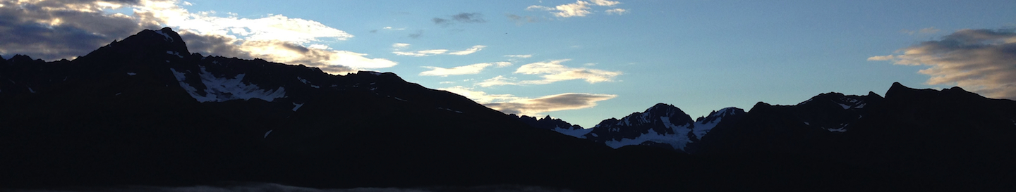
 On a voyage marked by exceptionally good weather, Red Bay gave us a misty, overcast day. From the ship, I was impressed by how beautiful it was. I love to be wrapped in the mystery of fog, especially beside the sea.
We had no excursions booked for this port, so I enjoyed a leisurely morning on board before making my way to the lower deck from which tenders depart. I wanted to minimize my time in crowds, and this was an excellent choice in that regard.
Click here to download PDF of HAL Daily Program front and back covers for this port.
First impressions
Red Bay was the first tender port on our itinerary. I’d taken a few cruises before, but never before had I availed myself of the tenders on a HAL vessel, plus my last cruise was several years prior to the pandemic.
How to board a cruise ship tender


Fortunately, the ship’s announcements make it easy to figure out where to go and what to do in every port, whether docked or using small tender boats to whisk passengers ashore.
The only possible mistake is not having your stateroom television tuned to the appropriate channel to make public announcements audible in private rooms. Those waiting in public areas will hear all broadcasts by the ship’s officers, but only vital ones are piped into cabins.
I made my way to the lower deck from which tenders depart, and found just a few people waiting the next trip. Another newbie mistake is failing to note when the last tender will return to the ship, or not synchronizing your personal timepiece to the correct local time. We had until 15:30 in Red Bay.
If you’ve never tendered from a cruise ship before, you should understand that you will be scanned on and off the ship in the interior hallway, just as you would be when docked. Ship’s security mans two podiums at all times when guests traverse the passage, checking identification for everyone.
Even anchored offshore, no one can wander onto a cruise ship!
There is a fairly steep staircase down to water level where several crew members are on duty to lend a hand; no corners are cut on safety here! Just be aware, if you are very anxious, that you are exposed to the elements on the ship side when boarding a tender, and it can be colder/wetter near the water line.
 For those using wheelchairs, staff will escort you through a different part of the ship—via elevator, perhaps in a service passageway—and bring you out at the water line through a different hatch. I didn’t take part in that process to offer more details, but I saw other passengers with these escorts.
Those with mobility impairments are seated right near the tender doors, eliminating the need to manage the small boat’s two interior steps. This can be the most exposed area, however, to wind and sea spray.
It seems likely you should allow additional time going ashore if extra assistance is required because it is clearly a very manual process involving multiple crew members.
 Sea conditions were smooth in the morning, but worsened by my return trip, and a good sized wave managed to splash through the open side doors of the tender I took back to the ship. A few people sitting right next to the door got wet. That’s the only time I saw a wave enter a tender during this trip, but passengers on the level benches at the door would be in the position most likely to experience this issue.
In Red Bay, I went ashore alone. Our family opted to self-isolate for the first few days of our journey, reducing any readily avoidable risk of catching COVID as much as possible before we made it to Greenland, a must see port of call for my husband. To this day, we avoid all densely populated indoor environments.
Perhaps in response to their mother’s love of travel, my kids can be a bit blasé about visiting new places. They also adore sea days on a cruise ship. Both teens stayed on board with my husband while I went to Red Bay.
 Red Bay port dock
For a tiny cruise port, Red Bay offered a very level, easy to traverse dock on its end. I hadn’t yet gotten into the habit of swapping my ship’s key card for my iPhone on my neck lanyard, so I didn’t get any pictures of the walkway as I used it.
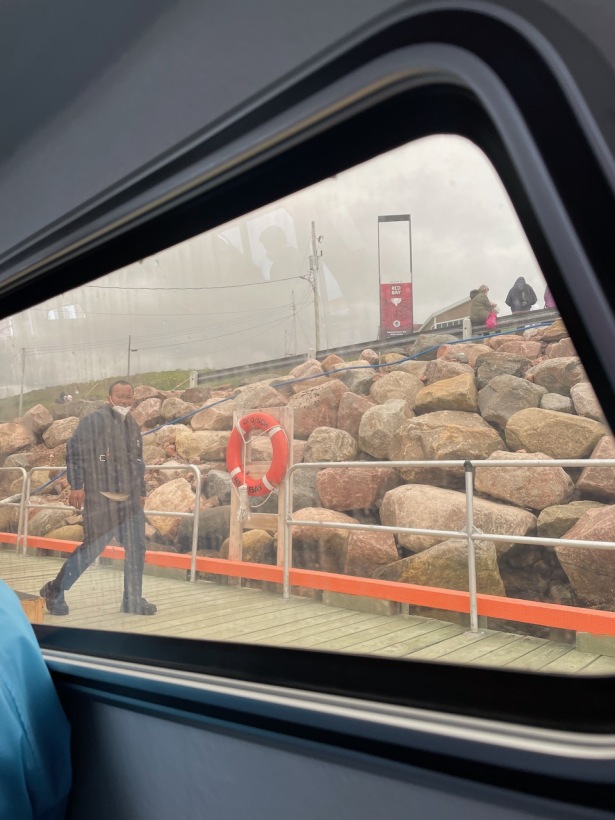 I did catch this snapshot of the Red Bay dock from my seat inside the tender, through the window.
The decking was smooth with no obstructions ready to catch unsteady feet. As in every port, the ship’s crew set out a small portable step, but someone was constantly available to offer a hand for those who needed it.
A portable ramp is offered on just some of the tenders, and it is extended as needed for wheelchair users. You may have to wait for the correct boat’s arrival if you require the ramp.
 Like many coastal areas, there was a slope up and away from the ocean, but Red Bay didn’t feel exceptionally hilly.
There were no sidewalks, and occasional vehicles seemed to express frustration via slightly aggressive driving with having so many distracted pedestrians wandering along a highway. Compared to most major cities, typical drivers here were quite considerate to pedestrians, however.
Cell phone safety for fumble fingers on the dock
My arthritis gives me fumble fingers, so I only hand-carry my phone in precarious circumstances if I’ve got it tethered to my body. Every tender port presented multiple situations where I feared dropping it into the sea. These were also frequently times where I wanted to capture memories of what conditions were like or where I’d been.
I use BlackRapid Tether Tabs—adhered to my hard case, not the iPhone itself—to create an anchor point for a lanyard or other strap. Buy Tether Tabs direct where a 3 pack costs $16.95 or from Amazon for $14.90 a pair.


After this first tender port, I got into the habit of physically tethering my phone before setting out from the ship’s lobby. To feel safe and comfortable, I need to keep both hands on both side railings while moving between the ship and its tender.
I learned about keeping three points of contact at all times from a TV show about firemen, but the idea is sound and endorsed by OSHA.
Walking around scenic Red Bay
With no excursion, I simply walked around the small, rural town, soaking in the atmosphere and taking pictures. I found it to be a scenic place, though I kept hoping the sun would properly break through. It teased, but never really shone for us that day.
 I do love the look of almost-sun in a nebulous sky, however, and got plenty of photos I really like.


")
This was one of the ports where the huge number of cruise ship passengers relative to locals was really noticeable. Red Bay’s population in the very low hundreds is trivial compared to Nieuw Statendam’s 2666 passenger capacity.

")
One of my favorite photos from the entire trip is of a simple pair of red Adirondack chairs at the end of a weathered dock looking out over the foggy ocean. Somehow, this sums up what I like best about the sea.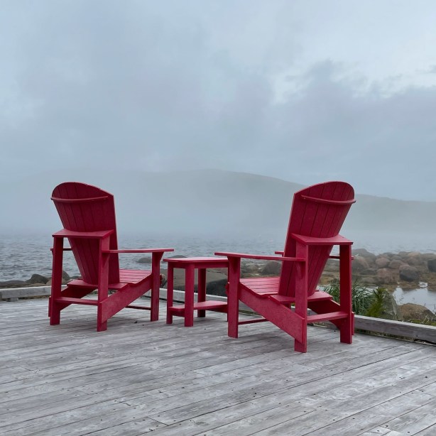
Obviously, that isn’t sunscreen and swimwear!
Weather & climate in Red Bay, Labrador
For August 7th, typical weather conditions in Red Bay are a high of 65ºF with a low of 58ºF. Sunrise was at 05:49; sunset at 20:54.
Aside from overcast skies, I didn’t need any special gear to handle the summer weather at this port. I wore my jacket because it looked like rain, but the abundant clouds never opened up. Unless you plan a long hike, I think it is safe to dress as you would for most other northern coastal areas.
I.e., the weather can always turn quickly near the sea, but Red Bay’s summer climate is not extreme.
Standard walking shoes will be adequate for moving around the town, though side roads were often gravel as opposed to asphalt.
I’ve read reports of the insects being terrible here, but I did not need my head net in Red Bay.
Shore Excursions by Holland America Line
I wish I could offer more information about tourism in Red Bay, but my family’s higher than average degree of COVID caution meant I had to skip any indoor exploration or shared vehicle in this port.
We did not book or take any HAL excursions here. The only offerings were a $70 walking tour or two different bus tours priced at $260 for 6.5 hrs or $150 for 4.5 hrs. All of these sold out in advance during 2022, the summer of “revenge travel.”
In general, I find walking tours sold by any cruise line overpriced. Usually, I can visit the same places on my own and learn just as much. I was particularly concerned about going into what I assumed would be a small visitor center in a large crowd, but I did find myself wishing for a local to ask about some of what I saw on my own in Red Bay.
 For example, I still don’t know what the huge, teepee shaped piles of logs were that I could see in the distance.
 Those structures do remind me vaguely of a friend’s art installation elsewhere on the Atlantic coast, though.
The town offered a free, one page pamphlet; click here for to download the PDF. I appreciate when a locality provides a printed map like this one for visiting tourists.
The Red Bay National Historic Site Interpretation Centre was stuffed with other passengers, so I didn’t take the risk of infection to view the chalupa* recovered from the sea bed or their other exhibits. Here’s the official Canadian government site for the national park.
 We bought an annual Canadian national parks pass, the Discovery Pass, which would have covered entry fees into this site. Our family of four broke even on the CAD145 pass after visiting just four Parks Canada sites; the cheapskate in me wishes we’d used it at all of the many possible sites at the ports we visited.
Note: Parks Canada is the organization equivalent to the U.S. National Parks Service.
Tickets for the boat to nearby Saddle Island were sold out, and I wasn’t yet ready to take the risk that it would be a small or enclosed vessel anyway. Some said the walking tour there was the highlight of this stop.
 I went inside the gift shop/restaurant near the visitor’s center just long enough to buy a Labrador flag sticker to add to my hard sided luggage. The lady working at the counter was friendly and kind, but it was obvious that capacity was strained in this venue. I found it uncomfortably crowded indoors.
The smell of food cooking in that tiny restaurant bursting with Holland America passengers is what finally nudged me back to the ship before the last tender. I was hungry, but there was no other obvious place to buy food in town.
My visit to Red Bay with a couple of thousand other tourists was pleasant… but frustrating. It left me quite eager to return on a day when the town hosts more a more typical level of visitors. I’m thinking car camping, travel by RV, or taking a sailor friend up on joining him for a bare boat charter might be the way to go.
I’m certain Red Bay still has a lot to offer that I have yet to see.
Other links to information about Red Bay
- CruiseCritic information about Red Bay
- What’s in Port link for Red Bay, Labrador
- CruiseLine link for Red Bay
♦
* No, not a Taco Bell special, but a fishing boat. The Basque spelling is txalupa, and here’s the Wikipedia link for general information on these historic vessels.
This post includes a review of a company in which I have a financial interest. I own enough shares of stock in Holland America Line’s parent company, CCL, to earn their Shareholder Benefit when I travel with any of their subsidiaries. This post is not intended to offer financial or investment advice; it represents my personal experience as a paying cruise passenger.
My cruise was booked through a travel agent at a standard, published rate.
I will never post an opinion behind which I’m unwilling to stand, but I promise to always be transparent about whether I will realize monetary gain from a reader taking my advice on a product or service.
 I specifically chose to assess laminated or coated paper maps that resist tears and spills because those make the most sense for the rigors of travel. Murphy’s Law suggests that we are most likely to get lost after the downpour begins; I’d like my map to function regardless of the weather.
 There’s an electrician’s shop on beachfront property. Industrial spaces like these have been gentrified in every seaside town I’ve visited in the USA. Driving along Highway 6 from Greymouth, you’ll see cows in a pasture with a view. More than a view, this is 100% ocean frontage, and the cows don’t even appreciate their prime real estate. They just stand there nibbling the ever-growing grass as the Tasman Sea churns beside them.
 Having arrived on the TranzAlpine train to an hour of heavy downpours in Greymouth, we learned immediately to appreciate the sun when it showed its face. Make hay–or make merry!–as soon as the sun shines.
 The primary car park at Hokitika Gorge was full by 10 AM, but the overflow lot had plenty of space when we arrived. Parking looked a bit more difficult closer to noon, but there were definitely still spaces available. I’ve found that most popular tourist destinations are best seen either early or late in the designated hours, and that seemed to hold true here.